We can't find the internet
Attempting to reconnect
Something went wrong!
Hang in there while we get back on track
For years I’ve used InfluxDB as my main database for logging all kinds of time-based data. It’s reliable, lightweight, and well-suited for storing metrics or events. One of the more personal data streams I collect is my own location history, captured through OwnTracks on Android. The app continuously sends geo-coordinates to my server, where they’re stored in InfluxDB.
Until now, my usage was simple: I would pull up a map view of a single day or a couple of weeks and see where I had been. It was more about having a “quantified self” archive than about running complex analysis. Recently, though, I started asking: what’s possible if I treat this data more seriously?
Setting up Geo-Temporal Data in InfluxDB
OwnTracks logs latitude/longitude points every few minutes. In my case:
- Around 91,000 points per year (every 6 minutes).
- A single day of data is easy to visualize, but over longer time spans, performance matters.
- I wanted to test whether InfluxDB’s S2 index could make queries faster when filtering spatially. Thanks Matthias for the hint :)
The S2 index is a way of mapping latitude/longitude coordinates onto a hierarchical cell system that’s easier to query than raw floats. Instead of searching through raw coordinates, InfluxDB can quickly filter based on cell IDs.
Performance Benchmark
I compared two setups:
-
With
s2_cell_idpresent: data stored with precomputed S2 cell IDs. - On the fly: InfluxDB computes S2 cells during query time.
Dataset: one year of data (~91k points).
Typical filter returned ~2,300 points (≈2.5%).
Results
| Query type | With S2 index | On the fly |
|---|---|---|
| Raw data (wide form) | 7.18s | 13.1s |
| Filter @ level 10 | 7.49s | 20.48s |
| Filter @ level 11 | 8.28s | 21.37s |
| Filter @ level 12 | 11.16s | 24.05s |
Observations
- Even with S2 indexing, base query cost dominates: fetching raw data is the main bottleneck.
- The index does help: filtering is roughly 2–3× faster compared to on-the-fly calculations.
- Increasing resolution (higher S2 levels) increases query time, so there’s a trade-off between spatial precision and performance.
A Short Note on S2 Geometry
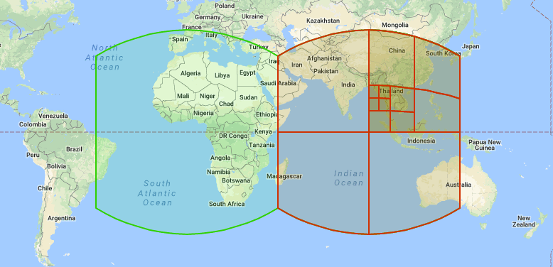
S2 is a geometry library originally developed at Google. Its core idea is to represent the Earth’s surface by projecting it onto the faces of a cube, which is then subdivided recursively into cells by using Hilbert curves. S2 Geometry
- Each S2 cell is identified by a unique integer ID.
- Cells can be subdivided hierarchically, so you can choose different levels of resolution (coarse regions vs. fine-grained areas).
- This makes spatial queries (like “points within this area”) much faster than comparing raw lat/long values.
In short: S2 turns messy geo data into something databases can index efficiently.
And now
So far, my experiments confirm that S2 indexing is useful for speeding up geo-temporal queries in InfluxDB, but the raw data size and query design still matter a lot.
For my personal use case — reviewing trips, walks, and places I’ve been — the current performance is good enough. But this exploration opens doors:
- Building aggregate views (e.g. heatmaps of most-visited areas).
- Running long-term analyses (seasonal mobility, time spent in places).
- Integrating with visualization tools beyond simple day-by-day maps.
InfluxDB, OwnTracks, and S2 indexing give me an okayish base. The next step is to think less like a log collector and more like a geospatial analyst. Well the last sentence I would not have written myself. Otherwise I am good creating the blog post with the help of ChatGPT.
